Information Technology (IT) and Business Process Outsourcing (BPO)
MySTI Certified
STI202500672

TuxGeo+ Platform

Tuxuri Sdn. Bhd.

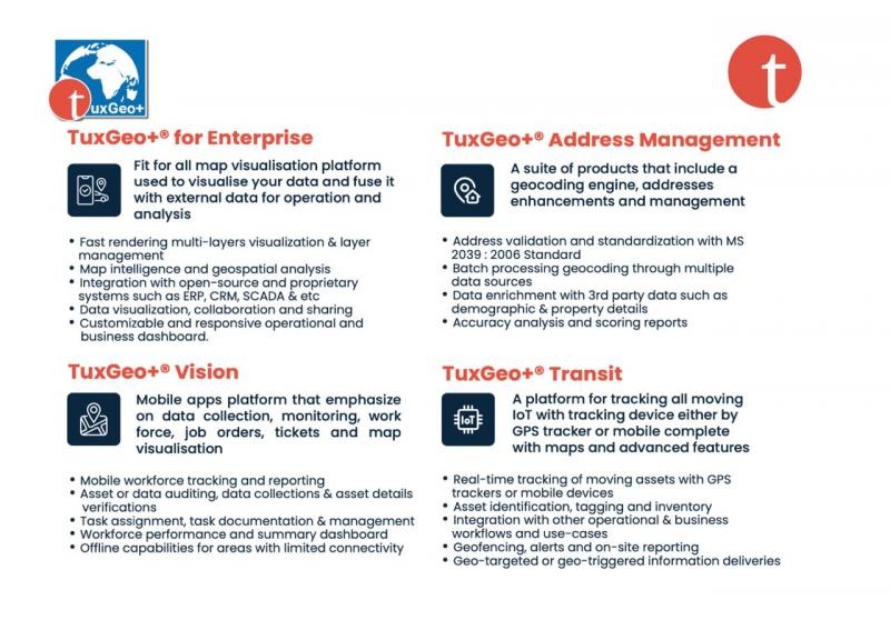
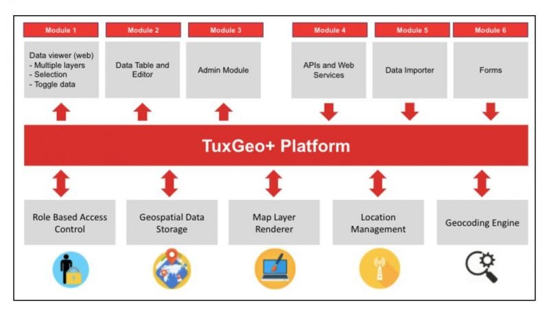
TuxGeo+ Platform is a Geo Web platform that unlocks the value of your business data by analysing and enriching them with meaningful location related information. It is a fit for all map visualisation platform used to visualise your data and fuse it with external data for operation and analysis. Some of the features of this platform are fast rendering multi-layers visualization & layer management, map intelligence and geospatial analysis, data visualization, collaboration and sharing, customizable and responsive operational and business dashboard, and integration with open-source and proprietary systems such as ERP, CRM, SCADA & etc. TuxGeo+ platform also includes our proprietary address management solution that contains geocoding engine and address enhancement, mobile apps platform that emphasize on data collection, monitoring, work force, job orders, tickets and map visualisation, IoT platform for tracking all static and moving IoT with tracking device either by GPS tracker or mobile complete with maps and advanced features for IoT data monitoring, alerts, record keeping and analysis.

SSM Registration Number
924477-U
ePerolehan Number
eP-1008I06U3
Indicative Price
MYR 165,000.00
Company Email Address
sales@tuxuri.com
No items found.

Recommended Market Segment

Use Cases

Unique Selling Proposition

star

Locally developed product

The TuxGeo+ product is a locally developed product registered with myIPO ensuring local knowledge of the industry, locally available support and expertise.

star

Simple licensing structure

Having experience in the local market, we devised our licensing structure to be simpler than our competitors, focusing on metrics such as concurrent users instead of number of users or limiting to number of infrastructure (core and server). We also include most of our microservices into our license instead of offering it piecemeal basis to our clients, ensuring no confusion to clients IT team and business users.

star

Location services and map data agnostic

Unlike other location intelligence platform, TuxGeo+ platform able to use any and multiple location services and map data providers locally or internationally (e.g. Google Maps API, Grab Maps API, HERE Maps API, TomTom Maps API etc.) to power the features, visualisation and analytics in the platform concurrently

star

Readily deployable in any cloud platform

Using container technology such as Docker and Kubernetes, the TuxGeo+ platform can be deployed fast, secure and scaleable in any cloud platform and Virtual Machines ensuring agile updates and support to clients.

star

Certified by Open Geospatial Consortium

TuxGeo+ platform and its microservices are certified by the international governing body of geospatial standard, the Open Geospatial Consortium (OGC)

star